Understanding Check Points in Aura
What are Check Points?
Check Points are surveyed reference points used only for validation. In surveying and mapping practice they may also be called check measurements, check stations, or independent validation points. Unlike control points, which influence the dataset during georeferencing or adjustment, Check Points remain outside the correction process. Their purpose is to provide an unbiased measure of accuracy, giving assurance that deliverables meet project specifications or regulatory standards.
How Check Points work in Aura
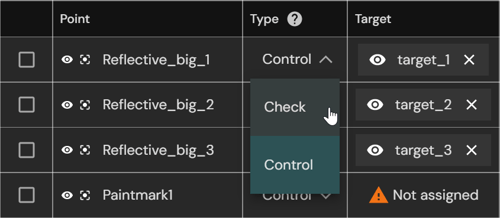
During the Ground Control Point (GCP) workflow, Check Points can be included in the same CSV file as control points. When assigning targets, selected points can be marked as Check Points to exclude them from SLAM correction and georeferencing correction.
Aura compares the coordinates of the Check Points with the corresponding coordinates derived from the point cloud target locations. The differences (residuals) between the reference coordinates and the point cloud coordinates are calculated and reported in the GCP accuracy report. This independent dataset confirms the accuracy of the processed point cloud without influencing the correction process.

Using Check Points helps you:
-
Verify scan accuracy after georeferencing.
-
Provide documented quality assurance for deliverables.
-
Demonstrate compliance with industry standards that require independent accuracy checks.
-
Increase confidence in Simultaneous Localization and Mapping (SLAM) results.\
Not every surveyed point should be used for georeferencing. Reserving some points as Check Points ensures that an independent dataset is available for validation, rather than allowing all points to influence SLAM correction or georeferencing correction.
How to Use Check Points
Check Points are included in the same survey CSV file as control points. During the Georeferencing with Ground Control Points (GCPs) workflow, you can nominate individual targets as Check Points. These points are excluded from correction and used only for accuracy validation.
For detailed instructions, see the Georeferencing with Ground Control Points (GCPs) workflow in the Knowledge Base.
Accuracy reporting with Check Points
When you include Check Points in your survey CSV and assign them during the GCP workflow, Aura calculates their positional difference against the processed point cloud. These residuals are summarized in the accuracy report alongside control point results.
The report includes:
-
Check Point summary: Average and Root Mean Square (RMS) error values across all Check Points, showing how closely the processed point cloud matches surveyed ground-truth coordinates.
-
Per-point residuals: Pre-SLAM alignment errors and final errors (X, Y, Z, and 3D) for each Check Point.
-
Control Point summary: Accuracy results for the points used in georeferencing, shown separately for comparison.
Check Points influence reporting by providing:
-
Independent validation: Residuals provide an unbiased measure of scan accuracy.
-
Context for deliverables: Accuracy evidence for stakeholders and clients.
-
Early error detection: Large residuals can flag survey mistakes, target misassignments, or SLAM drift.
-
Quality assurance: Supports compliance with industry standards and builds confidence in results.
FAQ
For answers to common questions, see the Check Points FAQ.
