Scanning techniques
This article outlines a number of scanning techniques that will help to produce a quality scan.
Contents
Scan size
While Hovermap has the ability to perform large scans, and the capacity to store up to 8 hours of scan data, we recommend performing multiple smaller scans instead of larger scans. There are many good reasons for this:
-
Smaller scans are often more accurate than larger ones as they will accumulate less drift.
-
A slip in a small scan will have less impact on a large multi-scan job.
-
Breaking your mission into smaller scans allows you to start processing while you are still scanning other areas. This allows for a faster overall process and gives you the ability to check scan quality as you go.
-
Multiple smaller scans are more easily copied, processed, and managed.
-
Smaller scans greatly reduce processing and RAM requirements.
Tips for smaller scans
- Aim for the scan time to be less than 35 minutes.
- When surveying a large area in multiple small missions, it is important that you plan your scanning pattern. Go to Scan patterns for more information.
- Ensure that there is some overlap between scans that you intend to merge. We recommend at least 20% overlap between scans.
Scan patterns
Closing the loop
One of the most effective ways to eliminate drift and to increase SLAM accuracy is through a practice called “closing the loop”. This means that you should stop your scan in the same general area where you started it. This location does not have to be exact.
Closing the loop works by helping Hovermap to connect features at the end of a scan, where the most drift has accumulated, to the features at the start of a scan, where there is no drift.
Try to close the loop as often as possible during the scan itself by creating many smaller loops along the way, as shown in the following image. In this case, the scan path starts in the center of the room, then loops around each row of desks before moving to the other side of the room.
By creating lots of smaller loops, SLAM will build a number of smaller “local” maps. Hovermap will then attempt to align these local maps (based on overlapping features) to produce a more accurate “global” map.

Grid pattern
Another alternative is to scan in a grid pattern. By doing this, Hovermap can generate denser and more accurate maps. This pattern allows large areas to be covered in a short space of time. When using this scanning pattern, we recommend that you travel at 5 meters per second, and use a 40 m grid. We also recommend at least 20% overlap between each square of the grid.
Use the following as a guideline:
- Walking scans: Make sure that your movements are as slow and fluid as possible.
- Drone-mounted scans: Keep your speed below 5 meters per second.
- Vehicle-mounted scans: Keep your speed below 20 kilometers per hour (12 miles per hour).
This gives Hovermap enough time to analyze the features in its environment and to piece them together. Moving faster than this can cause Hovermap to lose its place, which can distort your data.
Transitions
Sometimes when performing a scan, you will need to transition between two different environments or “scenes”. This is an issue generally encountered in indoor environments. For example:
- Moving between two different rooms
- Going around a corner
- Moving between two different levels of a building
- Going outside at the end of an indoor scan
When making these transitions, it is important that you move in such a way that Hovermap can see both where it has been and where it is going at the same time. If you are going through a doorway, for example, you would move through the doorway slowly sideways so that Hovermap can see both the old room and the new room. In this situation, it is a good idea to focus on the doorframe as you move through it, so that Hovermap has a feature that it can recognize in both rooms.
When going around a corner, take the widest path possible and give Hovermap some time at the apex to see both the old and new environments together before proceeding.
These techniques allow Hovermap to continue to build an accurate map as it moves. If you move too quickly, Hovermap will lose track of where it is, and a SLAM slip may occur.
Scan height
The height you should fly at will be determined by your environment. In environments with lots of features, you will be able to fly higher than in environments with relatively few features. The best practice is to determine the lowest possible height you can fly to efficiently cover the area required.
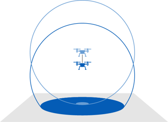
It is important to be aware that the higher you fly, the less ground coverage you will have, as shown in the following image. If you don’t have sufficient ground coverage, Hovermap can more easily lose track of any features on the ground, which can result in a SLAM slip.
For this reason, we recommend that you fly no higher than 40 m. Even at this height, you will need to be careful, as the data can become distorted if the environment lacks distinct features.

